Cyclone information
Living in Port Hedland means being prepared for tropical cyclones. As one of the most cyclone-prone regions in Australia, our community experiences a cyclone season that typically runs from 1st November to 30th April. During this time, severe weather can bring damaging winds, heavy rainfall, flooding and storm surges that may impact homes, businesses and essential services.
This page provides important information to help residents, visitors and businesses understand cyclone risks, prepare ahead of time, stay informed during an event, and recover safely afterwards. Being prepared and knowing what to do before, during and after a cyclone can help protect lives, property and our community.
For the latest warnings and emergency information, always follow advice from the Bureau of Meteorology and emergency services.
What is a tropical cyclone?
Port Hedland is one of Australia's most cyclone-prone regions, with the cyclone season typically running from November to April each year. Tropical cyclones are powerful weather systems that can bring destructive winds, heavy rainfall, flooding and storm surge, posing significant risks to people, property and infrastructure.
Our community has experienced the impacts of severe cyclones in the past, including Tropical Cyclone George in 2007, which brought wind gusts estimated at around 200 km/h and caused widespread damage across the region. These events serve as an important reminder of why cyclone preparedness is essential for everyone who lives, works or visits Port Hedland.
The effects of a cyclone can extend well beyond strong winds. Heavy rainfall can lead to flash flooding, roads may become impassable, and power, water and communication services can be disrupted. Flying debris and dangerous weather conditions can also make it unsafe to travel or be outdoors.
By understanding the risks, preparing your property and emergency supplies, and staying informed through official warnings and advice, you can help protect yourself, your family and our community when a cyclone threatens.
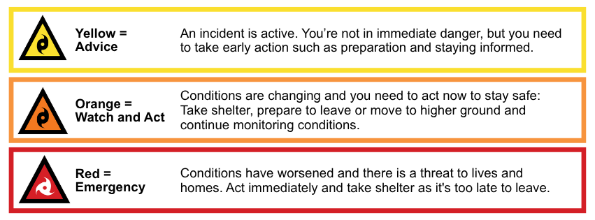
Understanding the Australian Warning System
The Australian Warning System (AWS) provides a consistent way to communicate emergency warnings across Australia, including for cyclones, bushfires, floods and severe weather. Department of Fire and Emergency Services issue alerts when a cyclone is approaching. The three stages of alerts are: Advice, Watch and Act and Emergency Warning.
Using simple warning levels, clear icons and practical safety advice, the system helps people understand the level of risk and what action they should take. Whether you're at home, at work or travelling, the AWS makes it easier to recognise warnings and stay informed during an emergency.
For more information, please visit: Prepare for a cyclone - Department of Fire and Emergency Services
Where can I get updates or further information?
Notable Port Hedland Cyclones
Tropical Cyclone Joan (December, 1975):
Severe Tropical Cyclone George (March, 2007):
- Severe Tropical Cyclone George crossed the coast as a Category 5 system 50km northeast of Port Hedland.
- Wind gusts of up to 275km/h, with a 10-minute mean of 194km/h, were recorded at Bedout Island, and 154km/h gusts were recorded at Port Hedland airport.
- Sadly, three people lost their lives during Severe Tropical Cyclone George.
- Severe Tropical Cyclone George, Bureau of Meteorology
Cyclone categories
| Category |
Maximum Wind Speed (km/h) |
Typical Strongest Gust (km/h) |
Typical Effects |
| 1 |
63 - 88
|
< 125
|
Damaging winds. Negligible house damage. Damage to some crops, trees and caravans. Craft may drag moorings.
|
|
2
|
89 - 117
|
125 – 164
|
Destructive winds. Minor house damage. Significant damage to signs, trees and caravans. Heavy damage to some crops. Risk of power failure. Small craft may break moorings.
|
|
3
|
118 - 159
|
165 - 224
|
Very destructive winds. Some roof and structural damage. Some caravans destroyed. Power failures likely.
|
|
4
|
160 - 199
|
225 - 279
|
Significant roofing loss and structural damage. Many caravans destroyed and blown away. Dangerous airborne debris. Widespread power failures.
|
|
5
|
> 200
|
> 279
|
Extremely dangerous with widespread destruction.
|
Cyclone preparation
Getting your property ready for cyclone season is one of the most important things you can do.
Preparing early can help reduce damage to your home and belongings, and may help protect lives during a cyclone.
The State Emergency Service (SES) and the Town of Port Hedland recommend completing the following before 1 November:
- Remove unwanted items, debris and rubbish from around your home or workplace.
- Trim trees and overgrown branches to help them withstand strong winds.
- Clear gutters, drains and stormwater systems of leaves, rubbish and other blockages.
- Create or update your Family Cyclone Plan.
- Prepare an emergency kit and make sure you have enough drinking water for your household.
- Decide where your pets will stay during a cyclone.
- Arrange tie-down points and equipment to secure caravans, boats, trailers and other large outdoor items that could become dangerous in high winds.
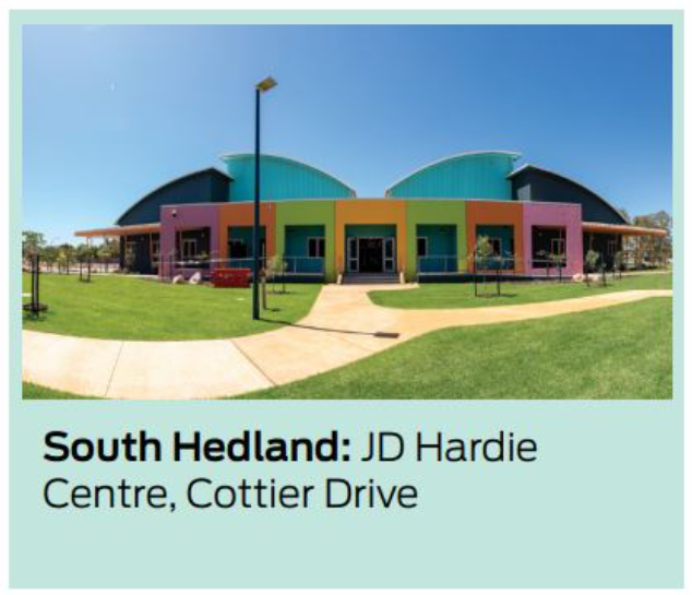
Welfare centres
When there is a cyclone warning, the lead agency for all direction is the Department of Fire and Emergency Services.
If an evacuation centre is required, the Department of Fire and Emergency Services will work with the police and the Department of Communities to decide and advise.
If you need to evacuate, consider seeking refuge with a friend or colleague who lives on higher ground.
The welfare centre will only be opened on the advice of DFES/SES and manned by the Department of Communities.
For further information please contact the Department of Communities on (08) 9160 2800.
After a cyclone
Be aware that there may be debris or other hazards still present even after the all-clear has been given by authorities. Flood waters can clog storm water systems, and residents need to be aware of the dangers in or around storm drains, ditches, ravines or culverts as it is very easy to be washed away by fast-moving water.